


KATHMANDU. While Prime Minister Balendra (Balen) Shah recently raised the issue of territorial encroachment by neighboring countries in the Parliament, he maintained absolute silence regarding the northern border encroached upon by China, despite explicitly discussing the southern neighbor, India. Perhaps the Prime Minister lacks adequate information on this matter, or he chose not to speak due to diplomatic sensitivities. However, a special investigation and historical documents uncovered by Nepal Aaj expose alarming facts regarding historical as well as ongoing border encroachments by the Chinese side.
Nepal has consistently analyzed neighboring China merely as a reliable friend that provides selfless assistance and respects Nepal's integrity and sovereignty. Yet, a retrospective glance at history reveals a long chronicle of China bullying Nepal, encroaching upon its borders, and launching hostile attacks on Nepali security personnel since time immemorial.
1. Historical Background: Nepal-Tibet Relations and the Three Wars
Until 1949, Tibet existed as an independent sovereign nation. At that time, Nepal and Tibet shared a deeply complementary and robust commercial relationship. Tibetan and Nepali merchants traded in each other's territories without restrictions. However, relations between the two entities were not always peaceful. History records three major wars between Nepal and Tibet:
-
The First War (Vikram Samvat 1845): Tibet suffered a crushing defeat in this war and was compelled to bear the entire financial liability of the conflict.
-
The Second War (1788–1792 AD): Sparked by commercial disputes, Tibet sought the military intervention of the Chinese (Qing) Empire to launch an offensive against Nepal. This conflict lasted for nearly four years and concluded with an agreement in 1792 (The Treaty of Betrawati). According to that accord, China was designated to arbitrate any future disputes between Nepal and Tibet, and both nations had to pay an annual tribute (salami) to China—an arrangement that was fundamentally detrimental to Nepal's interests.
-
The Third War (Vikram Samvat 1911): Following fresh friction over specific bilateral matters, Nepal launched a military campaign against Tibet. Tibet expected assistance from China, but the Chinese forces failed to arrive. Ultimately, in Vikram Samvat 1912, Tibet signed the Treaty of Thapa thali, capitulating to all of Nepal's conditions.
While this historical relationship brought immense economic prosperity to Nepal's merchant class, the geopolitical landscape shifted dramatically in 1950. Following China's military invasion and annexation of Tibet, the existence of Tibet as an independent nation ceased, and China directly became Nepal's northern neighbor.
2. The Rise of China and the 'Salami Slicing' Strategy
Upon establishing a direct border, China intensified its military surveillance and began strictly regulating the traditional Nepal-Tibet trade routes. Since 1958, China has adopted a calculated 'Salami Slicing' strategy along Nepal's border areas. This geopolitical maneuver involves encroaching upon Nepali territory inch by inch, with the ultimate objective of seizing control over massive swaths of land.
As long as Tibet remained independent, bilateral frictions were strictly limited to commercial disputes rather than border delineations. Consequently, until 1948, no definitive cartographic evidence existed regarding the absolute border between Nepal and Tibet. However, if we accept the historical assertions of a prominent Nepali political party as a baseline, Nepal had historically enjoyed undisputed possession and administrative rights over territories extending south of the Brahmaputra River, and from Kailash Mansarovar to Shigatse. When the formal border demarcation between Nepal and China took place during the reign of King Mahendra, Nepal's territorial expanse was unjustly compromised, allowing China to dictate the boundary according to its own discretion.
3. The Mount Everest Dispute and the 1960 Military Aggression
In 1960, China published an official map encompassing Tibet, which unilaterally claimed the entirety of Mount Everest (Sagarmatha) within Chinese territory. Entangled in domestic political turmoil, the Nepali state was stunned by this provocative maneuver. As the Nepali public took to the streets in protest, the then Prime Minister B.P. Koirala embarked on an official visit to China. During bilateral negotiations, China aggressively claimed not only Mount Everest but the entire Mahalangur Himalayan range as its sovereign territory, pressuring the Nepali delegation to sign an accord based on Chinese maps.
When the Nepali delegation adamantly refused to capitulate, China proposed an alternative condition to bifurcate Mount Everest in half. Recognizing the deadlock, Prime Minister B.P. Koirala deferred the absolute resolution of the Everest dispute for a later date and returned after signing a general treaty of friendship. This compromise triggered fierce, nationwide anti-China protests organized by more than 18 civil organizations and political parties.
Meanwhile, during an official visit to the United States, King Mahendra stated in an international interview that Mount Everest legally belonged to Nepal and that China had fabricated a dispute without cause. This statement generated immense international pressure on Beijing. Consequently, the Chinese Prime Minister visited Nepal and proposed that the territory up to 17,000 feet north of Mount Everest would belong to China, while the remaining southern slopes would belong to Nepal. Nepal rejected this proposal, keeping the dispute unresolved.
The Military Attack Incident: Amidst this diplomatic standoff, in June 1960, Chinese armed forces crossed the border and launched a surprise attack on a Nepali border security post. The assault resulted in the casualty of one Nepali security personnel, while an additional one and a half dozen soldiers were taken hostage by the Chinese forces. Following a fierce diplomatic counter-offensive by Nepal, China unconditionally released the hostages and issued a formal apology.
Ultimately, a preliminary border demarcation agreement was reached during B.P. Koirala's tenure in April 1960, followed by the signing of the final Boundary Treaty on October 5, 1961, between King Mahendra and Chinese President Liu Shaoqi. This treaty established a 1,439.18 km long border, demarcated by 98 permanent pillars across 79 locations. Due to extreme geographical remoteness, pillars 33, 37, and 38 could not be installed initially. In 1989, a joint inspection committee noted that China had unilaterally constructed pillar number 33 in the absence of Nepali officials—a modification that the Nepali government has meekly confined to its official archives.
4. Nine Major Incidents of Chinese Encroachment on Nepali Territory
The arbitrary territorial violations executed by China from the eastern to the western sectors of the Nepali border are documented in various government and non-governmental reports as follows:
Incident 1 – Darchula: 18 Nepali Households Annexed by China

Interested in this ad?
Would you like to continue to the link or provide your information for more details?
Please provide your information
To continue, please fill in your details
Eighteen Nepali households in a locality called 'Jiujiu' in Darchula have fallen under Chinese territorial encroachment. According to a field investigation report by the National Human Rights Commission, although these properties were historically within Nepal's jurisdiction, the territory is currently under absolute Chinese control, while the Nepali government maintains an submissive silence.
Incident 2 – Humla: Unilateral Construction of a Canal Diverting Water to China
According to a highly confidential report submitted by a seven-member task force formed under the Sher Bahadur Deuba-led government (coordinated by the then Joint Secretary of the Ministry of Home Affairs, Jaya Narayan Acharya):
-
China attempted to permanently seize control of a crucial water source by constructing an unauthorized canal, road, and water tank inside Nepali territory in the Kit Khola region of Humla. These structures were subsequently dismantled by the Armed Police Force of Nepal.
-
The Chinese military erected wire fencing within Nepali territory at Kit Danda and Kit Khola, extending from the south of shared border pillar 5(2) and running north of pillar 6(1) all the way to the Karnali River.
-
China illegally installed a surveillance CCTV camera inside Nepali territory.
-
The aggressive surveillance by Chinese forces at the traditional Mansarovar viewing point in the Lolung area has severely disrupted the religious activities of Nepali pilgrims.
-
Border pillar 7(2) is physically missing from the ground, while China has erected fencing from pillar 9(2) to 10, directly violating the bilateral border protocol that strictly prohibits any permanent structures within a 10-meter buffer zone (No-Man's Land).
Incident 3 – Mustang: Military Infatuation and Permanent Structures
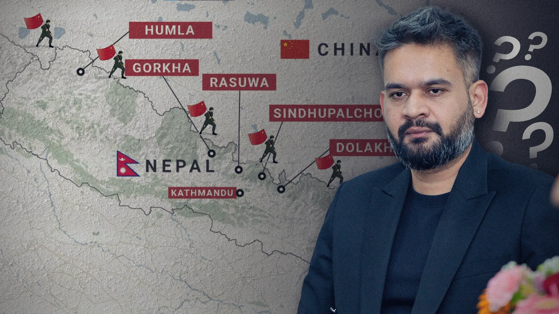
Mustang features 16 border pillars ranging from numbers 18 to 33. Local community leaders claim that pillar number 33 has been deliberately made to disappear by the Chinese military. Centering its operations around pillar number 24, China has encroached 50 to 60 meters beyond the historical border line, constructing pitched roads, massive military checkpoints, customs buildings, and a residential commercial complex containing 500 stalls. Consequently, Nepali citizens are barred from accessing the area, and a strategic uranium mine located near Lo Manthang has been completely encircled by Chinese infrastructure.
Incident 4 – Gorkha: An Entire Nepali Village Lost to China
Border pillars 35, 37, and 38 in northern Gorkha's Rui Village and Tom Khola sectors have entirely vanished. Because China unilaterally shifted pillar 35 further inside Nepal, Rui Village, comprising 72 households, has been under Chinese occupation for the last 63 years (since 1960). The displaced inhabitants still possess official legal receipts of land revenue paid to the Gorkha district administration. According to border expert Buddhi Narayan Shrestha, during the historical land-swap agreements, the land Nepal received in greater volume was substandard, rocky, and barren, whereas the territory ceded to China comprised fertile grazing pastures and established settlements.
Incident 5 – Sindhupalchok: 11 Hectares of Land Occupied
According to an official survey report submitted to the government on July 21, 2015, by the survey branch of the Ministry of Agriculture (which the state apparatus refrained from officially acknowledging due to geopolitical fear), data proved that China had encroached upon a total of 36 hectares of Nepali territory. Specifically, the report confirms the illegal occupation of 7 hectares in Kharane Khola and 4 hectares in the Bhote Koshi region of Sindhupalchok.
Incident 6 – Rasuwa: Land Seizure Across Four Key Locations
The same 2015 ministerial report reveals that China has systematically occupied vital land sectors along the Rasuwa border, including 2 hectares in Sanjen Khola, 1 hectare in Bhurjug Khola, 3 hectares in Jambu Khola, and a significant unquantified sector along the Lemde Khola.
Incident 7 – Dolakha: Misplacement of Pillar 57 and Cartographic Discrepancies
A severe territorial dispute exists regarding border marker number 57 in the Lapchi sector of Bigu Rural Municipality-1, Dolakha. The pillar, which legally belongs at the summit of the Korlang ridge, has been surreptitiously relocated approximately 1,500 meters downward into the Nepali base. This displacement has resulted in the loss of roughly 99 Ropanis of Nepali land to China. The National Human Rights Commission report confirms this violation. If this current altered marker is accepted as the boundary, the physical geography completely contradicts the official maps of Dolakha district and the nation.
Incident 8 – Solukhumbu: The Disappearance of Pillar 62
Border pillar number 62 in Nampa Bhanjyang, Solukhumbu, mysteriously vanished during the period when China laid claim to Mount Everest. Sources within the Survey Department indicate that the pillar was eventually relocated after the resolution of the Everest negotiations.
Incident 9 – Sankhuwasabha: Concrete Dams Endangering Nepali Settlements
In the Kimathanka sector along the Arun River border, China constructed a massive concrete embankment to safeguard its own commercial hub, Changga Bazaar. This infrastructure has redirected the river's high-velocity currents toward the Nepali banks, placing the Kimathanka settlement of Bhotkhola Rural Municipality-1 (comprising 100 households) at catastrophic risk of river erosion. Although the then Irrigation Minister Barshaman Pun conducted an aerial inspection via helicopter, the government failed to issue a diplomatic directive to Beijing. China has officially encroached upon 9 hectares in this sector: 3 hectares in Sumjug Khola, 2 hectares in Kam Khola, and 4 hectares along the Arun River.
5. The Illusion of Friendship and State Capitulation
Following the Chinese annexation of Tibet, the era of uninhibited cross-border movement and free trade between Nepal and Tibet ended, replaced by a pattern of unilaterally imposed border disputes. These territorial violations engineered by the Chinese state are systematically suppressed, rarely surfacing as news in mainstream media, leaving the general populace entirely oblivious.
Investigative reports compiled by various high-level task forces formed by the Government of Nepal are permanently hidden away in state archives out of a paranoid fear of jeopardizing diplomatic relations with Beijing. This ongoing administrative passivity demonstrates that China does not fully respect the bilateral border treaties signed with Nepal. Furthermore, the persistent hesitation of republican Nepal’s political class, including new leaders like Prime Minister Balen Shah, to even articulate these violations in Parliament proves a total failure in taking timely measures to defend the state's borders. The long-standing political narrative that 'China is a flawless friend that respects Nepal’s sovereignty' is increasingly exposed as an illusion.