
Harka Sampang Commits Treason Against ‘Greater Nepal’: Why Was China’s Occupied Territory Omitted?

Kathmandu — Tapping into nationalist sentiment and stirring political debate, Dharan Mayor Harka Sampang recently ignited controversy with the “Greater Nepal” map he published on Facebook. Posted via the “Harka Sampang A Revolution” page, the map includes territory from Kangda in the west to Tista in the east—but surprisingly omits the northern region long under Chinese control, a land emotionally tied to Nepal’s national pride.
In reality, historical evidence confirms that the authentic “Greater Nepal” once stretched from Mount Kailash and Mansarovar in the west to Singtche in the east. Territories northward, reaching as far as the Brahmaputra River, also formed part of Nepal, historians say. Yet those crucial and sensitive northern lands are absent from Sampang’s map, prompting social-media users to wonder whether he has bowed to Chinese expansionist pressure.
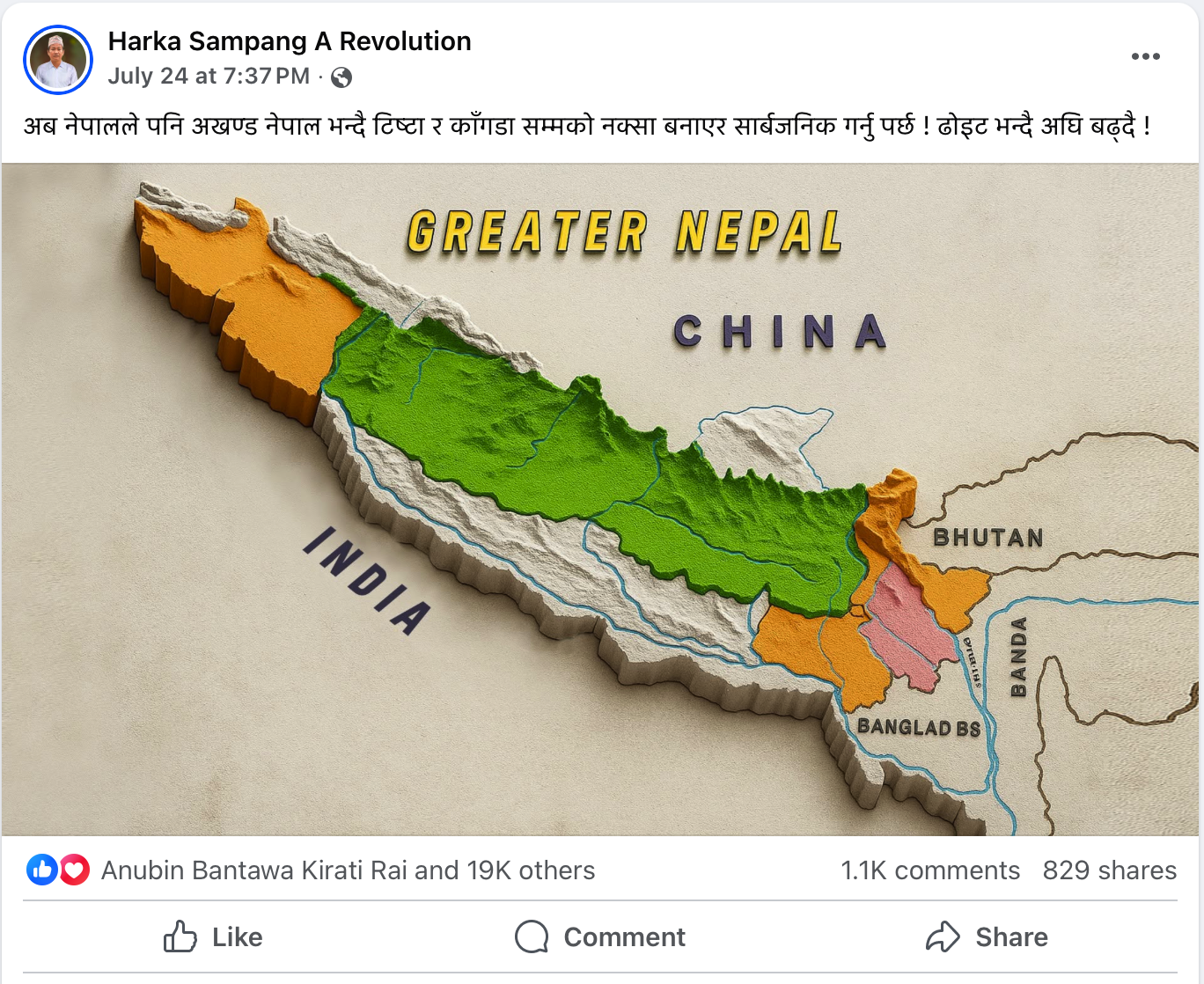
Within days of the post, more than 19,000 reactions, over 1,000 comments, and hundreds of shares underscored the public’s deep emotional response. Many accused Sampang of wounding Nepal’s national dignity by excluding Chinese-occupied regions. One Facebook user wrote, “Raising a dispute with India while staying silent on China’s occupation is grave treason.” Another challenged the mayor directly: “Mayor Sahib, what price have you paid by ignoring our northern border?”
The page’s “Town Hall, Manchester, UK” address has fueled further suspicion. Observers note that while the page appears to be run from abroad, many believe Sampang himself is the true operator—raising questions about whether this abroad-based façade is a deliberate tactic for sharing radical content.
Sampang’s supporters, however, dismiss such allegations as baseless, insisting the map was simply meant to awaken Nepali nationalism. They argue that posts like this are necessary for national consciousness. Still, the omission of the northern territories casts doubt on his true intentions.
When addressing such a sensitive issue of national identity, does highlighting one border while ignoring another strengthen unity or sow division? That question has become the focus of intense debate among citizens, intellectuals, and political circles. Is Sampang’s move genuinely motivated by concern for Nepali land, or is it influenced by external pressure? The people of Nepal will be seeking answers in the days ahead.
This is the link to his Facebook page: https://www.facebook.com/HarkaSampangRevolution
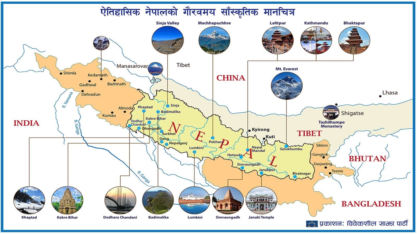
In Bibekseel Nepali’s map, “Greater Nepal” is clearly shown extending from Kailash–Mansarovar to the Brahmaputra River, whereas Phanindra Nepal’s map does not include that historical extension. If the “Harka Sampang A Revolution” Facebook page is indeed fake, why has he not taken any initiative to shut it down?


![From Kathmandu to the World: How Excel Students Are Winning Big [Admission Open]](https://nepalaaja.com/img/70194/medium/excel-college-info-eng-nep-2342.jpg)