Was the Recent Earthquake's Epicenter in Nepal? Did China Occupy the Land?

Nepal's Territories and China's Encroachment: Earthquake Brings Historical Disputes to the Fore
A recent earthquake, with its epicenter located 35 kilometers from Shigatse in the Dinggye region, has reignited discussions on the long-standing territorial disputes between Nepal and China. Striking at 6:50 AM, the earthquake not only caused tremors in the surrounding areas but also brought into focus questions about historically disputed territories. Dinggye, currently under Chinese control, is believed to have been part of Nepal's administered territory during the time when Tibet was an independent nation, as evidenced by old maps and historical records.
However, after China's annexation of Tibet in 1950, allegations arose that Beijing began unilaterally redrawing borders to suit its own interests. Until 1948, there were no border disputes between Nepal and Tibet. The relationship between the two neighbors was largely limited to trade. But following China's intervention, Nepal's historical claims to regions like Shigatse and Mansarovar were eroded.
Allegations of Chinese Encroachment on Nepali Land
For years, Nepal has accused China of encroaching on various border areas. These allegations have been reinforced by incidents in regions like Jiwu Jiwu in Darchula, Kit Khola in Humla, Rui Village in Gorkha, and Mustang, among others. The recent earthquake has once again underscored these concerns, making the issue more relevant than ever.
In Darchula, 18 houses are reported to be under Chinese control. In Humla, China is accused of constructing a permanent canal on Nepali land. Similarly, the disappearance of border pillar 35 in Gorkha has led to Rui Village, home to 72 Nepali households, falling under Chinese jurisdiction. Furthermore, incidents in Sindhupalchowk, where 11 hectares of land were allegedly encroached upon, and in Mustang, where Chinese forces built concrete structures, have raised serious questions about Nepal's territorial sovereignty.
Phanindra Nepal's Greater Nepal Campaign
Amid these concerns, Phanindra Nepal's "Greater Nepal" campaign has drawn significant attention. Recently, he unveiled a new map claiming an area of 334,250 square kilometers, which includes territories Nepal controlled before the 1816 Sugauli Treaty. While his supporters view this as a matter of national pride, critics argue that his research lacks depth and fails to address Chinese encroachment. Instead, his campaign has largely focused on the Nepal-India border disputes, raising questions about its comprehensiveness and credibility.
Nepal's territorial issues with India often dominate discussions, but the lack of attention to similar challenges posed by China undermines the effectiveness of campaigns like "Greater Nepal."
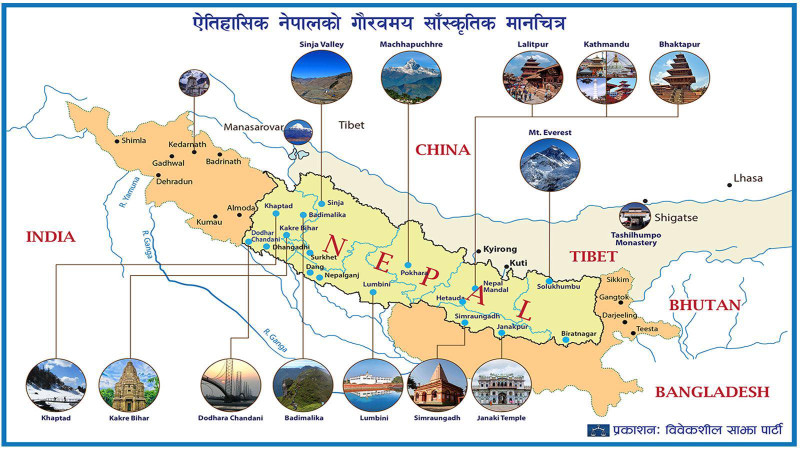
Bibeksheel Sajha's Cultural Map of Nepal
In a related development, the Bibeksheel Sajha Party recently released a cultural map of Nepal, highlighting the country's rich diversity and heritage. While the map aims to celebrate Nepal’s cultural identity, critics have noted its silence on the issue of Chinese encroachment. Some argue that such initiatives, while important, should also address geopolitical realities to avoid seeming detached from pressing national concerns.
The Need for Resolution
The recent earthquake has brought historical grievances and territorial disputes with China back into the spotlight. Campaigns by figures like Phanindra Nepal and initiatives by parties like Bibeksheel Sajha reflect differing approaches to asserting Nepal's sovereignty and cultural identity. However, without concrete evidence and practical solutions, these efforts risk being dismissed as emotional nationalism.
Nepal faces a pressing need to address the injustices of the past and the ongoing challenges of encroachment through robust national policies and diplomatic efforts. The questions raised by the earthquake’s epicenter underscore the importance of resolving these disputes to safeguard Nepal’s territorial integrity and sovereignty.


![From Kathmandu to the World: How Excel Students Are Winning Big [Admission Open]](https://nepalaaja.com/img/70194/medium/excel-college-info-eng-nep-2342.jpg)
